

The world’s first dual radar earth observation satellite ‘NISAR’ jointly built by the Indian Space Research Organization (ISRO) and NASA will be launched from Sriharikota on July 16. This satellite costing Rs 13 thousand crores will be used for monitoring deep inside the forests, movement of glaciers and ground water.
New Delhi: The world’s first dual radar earth observation satellite ‘NISAR’ will be launched on July 16 from Sriharikota in Andhra Pradesh. It has been jointly built by NASA and ISRO. It is the world’s first and most expensive earth observation satellite. It is capable of looking deep into the forests. It will be able to see every movement from the top to the bottom of the earth with its dual frequency dual band radar. This satellite mission, costing around Rs 13 thousand crores, will keep an eye on every small and big change happening on the earth, whether it is movement in the ground, deforestation, melting of glaciers or the condition of crops.
World’s first satellite to monitor the earth
Former ISRO scientist and scientist who has worked on this mission Radha Krishnan said that NISAR is different from the European agency’s satellite in the sense that it can easily see from top to bottom of forests. Be it the dense shade of trees or a thick layer of snow, it can accurately capture the changes happening underneath it.
He said that India’s Chandrayaan also has two L-band and S-band dual radars but it does not monitor the earth but collects moon data. NISAR is the world’s first satellite to monitor the earth which has radars of two different bands. This is the reason that it will easily collect data through radar even under dense forest.
In which works will it help
Monitoring of forest biomass: Will be able to see below the dense greenery of trees, will accurately assess how much forest is left or how much is being cut.
Eye on glacier movement: Will continuously monitor whether the ice is melting or the glaciers are sliding.
Tectonic study: Will detect the movement, cracks or gradual changes in the plates of the ground – helpful in giving warning before landslides.
Help in agriculture: Will provide information like condition of crops, soil moisture, condition of ground water.
Geosciences: Will study the long-term changes taking place in mountains, plains, rivers and the surface of the earth.
Water science: Will collect information related to river flow, floods, moisture in the soil, availability of water.
Help in natural disasters: Will provide clear pictures and data even in smoke, clouds or ashes during disasters like floods, fires, earthquakes or volcanic eruptions.
Why is NISAR different from the rest of the world?
World’s first Earth observation satellite equipped with dual radar
It has both L-band and S-band radars
Till now, European Space Agency’s Sentinel satellite works only on single radar
It will orbit the entire Earth every 12 days and provide updates
Satellites based on SAR technology
SAR satellites can take pictures of the earth’s surface both during day and night. Instead of taking direct pictures with the camera, they use radar signals to penetrate clouds, smoke and ash and give clear pictures. This is why these satellites are very useful during disasters like floods, forest fires or volcanic eruptions. Radar signals can reach deep inside dense forests and trees.
The Nissar
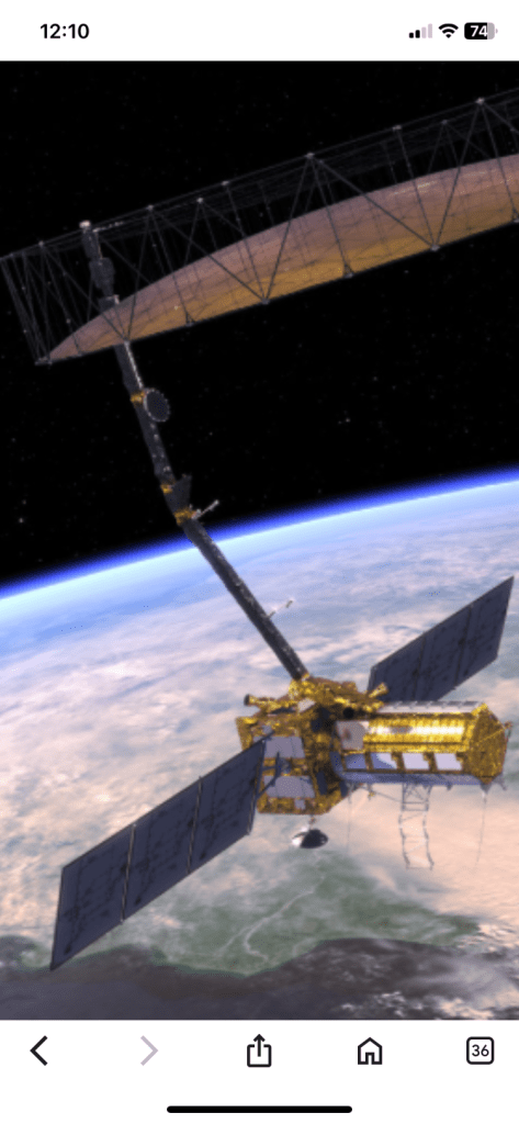
The NISAR (NASA-ISRO Synthetic Aperture Radar) satellite is a joint Earth observation mission between the National Aeronautics and Space Administration (NASA) of the United States and the Indian Space Research Organisation (ISRO).
Here’s a breakdown of key aspects:
- Joint Collaboration: It’s a significant partnership, marking the first time the US and India have collaborated on a radar-based Earth monitoring satellite from space.
- Purpose: NISAR’s primary objective is to observe and measure some of Earth’s most complex natural processes, including:
- Changes in ecosystems
- Ice mass and glacier flow rates
- Vegetation biomass
- Sea level rise
- Groundwater variations
- Natural hazards such as earthquakes, tsunamis, volcanoes, and landslides
- Dual-Frequency Radar: A key innovation of NISAR is that it will be the first radar imaging satellite to use dual frequencies:
- L-band radar (provided by NASA): This penetrates dense forests and soil, making it ideal for measuring ground motion, especially in volcanic and seismic zones.
- S-band radar (developed by ISRO): This improves surface monitoring precision and is particularly useful for observing soil moisture and polar regions.
- Imaging Capabilities:
- It will map the entire globe in 12 days, providing spatially and temporally consistent data.
- The radar can penetrate clouds and darkness, allowing for data collection day and night in any weather.
- It will provide high-resolution images (3-10 meters, mode-dependent) over a wide swath (greater than 240 kilometers).
- Launch:
- The satellite is planned to launch in 2025 from the Satish Dhawan Space Centre in Sriharikota, India, aboard ISRO’s Geosynchronous Satellite Launch Vehicle (GSLV).
- While various sources cite June or July 2025, the exact date is subject to final approvals and mission readiness.
- Mission Duration: The planned mission duration is 3 years, though it carries consumables for 5 years.
- Data Availability: All NISAR science data (L-band and S-band) will be freely available and open to the public, aligning with NASA’s Earth Science open data policy.
NISAR is expected to revolutionize our understanding of Earth’s dynamic systems and contribute significantly to resource management, disaster preparedness, and climate change studies.
Please like subscribe comment your precious comment on universe discoveries
Full article source google

🙏🌹
Aum Shanti
LikeLike
Well shared very informative 🙂
LikeLiked by 1 person